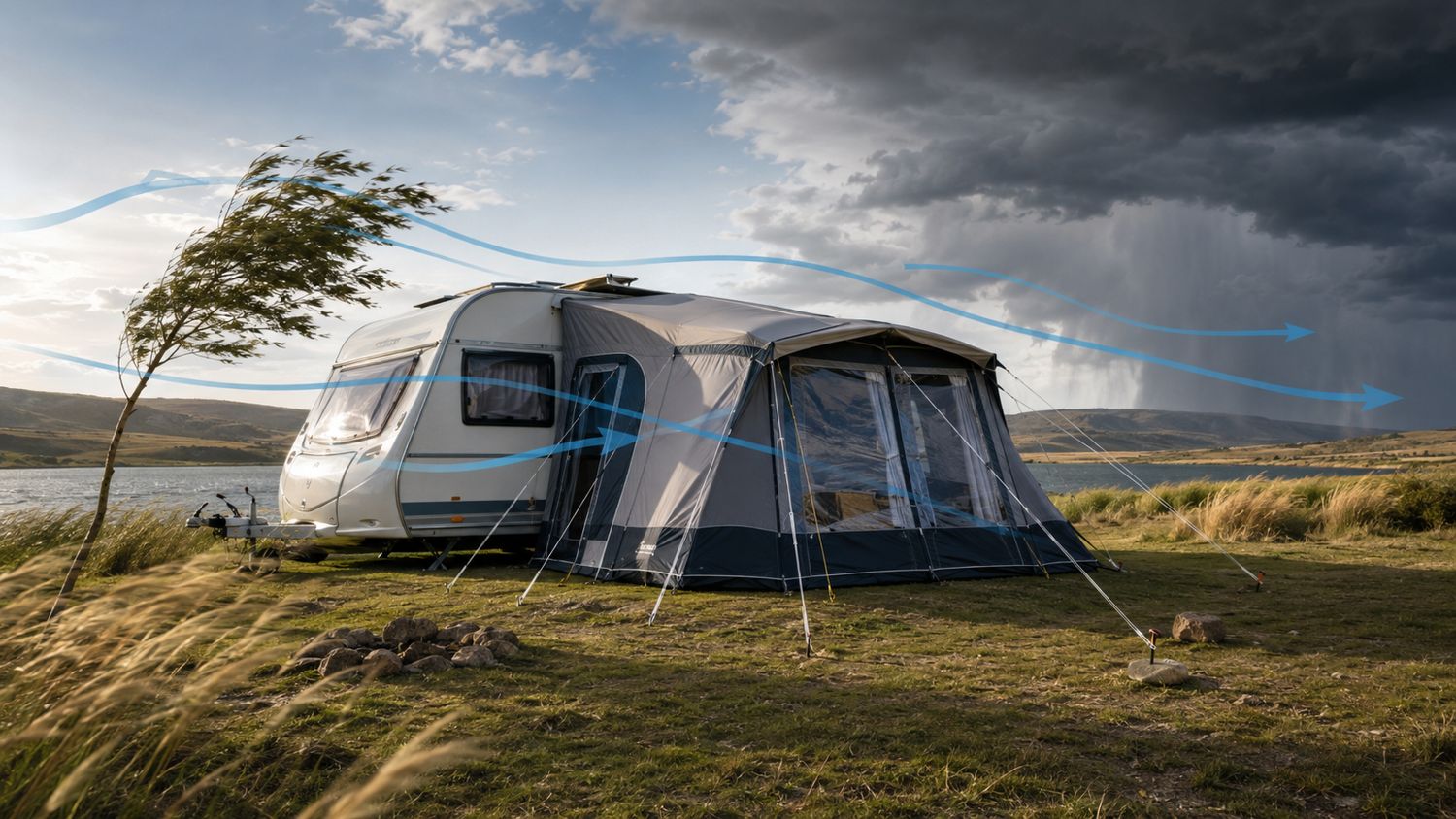
Wind is one of the hardest campsite conditions to judge.
Rain is visible. Temperature can be measured. Wind may be gentle at one moment and violent a few minutes later. It can also behave very differently at two campsites only a short distance apart.
A regional forecast may show moderate wind, while a campsite beside a dam experiences strong, uninterrupted airflow. Another site behind a hill may appear protected but receive sudden downward gusts and swirling turbulence.
This happens because the weather system creates the general wind, but the local landscape determines how that wind reaches your tent.
Campers therefore need to consider more than the predicted wind speed. You should also ask:
Where is the wind coming from?
What weather system is producing it?
How strong could the gusts become?
Could the direction change?
How will hills, trees, buildings or water affect it?
Which part of the tent will carry the greatest load?
Will the poles, ropes, pegs and ground work together?
The central lesson is simple:
Do not look at wind speed in isolation. Wind direction, gusts, terrain, tent shape, anchoring and duration all matter.
1. What Wind Is and Why It Moves
Wind is moving air.
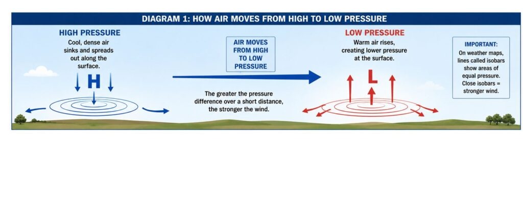
It starts because atmospheric pressure is not equal everywhere.
The sun heats the Earth unevenly. Dry land, water, mountains, vegetation, cities and cloud-covered areas all warm and cool at different rates. This creates differences in air temperature and pressure.
Warm air expands and becomes less dense. Cooler, denser air moves towards areas of lower pressure, creating wind.
A simplified version looks like this:
Higher pressure → moving air → lower pressure
The greater the pressure difference over a short distance, the stronger the wind can become.
What is atmospheric pressure?
Atmospheric pressure is the weight of the air above us.
On weather maps, lines called isobars connect places with the same atmospheric pressure.
When isobars are widely spaced, the pressure changes gradually and winds are usually lighter. When isobars are close together, the pressure changes quickly over a short distance and stronger wind is more likely.
Why does wind not move in a straight line?
The Earth is rotating.
This rotation deflects moving air. In the Southern Hemisphere, the movement is deflected towards the left.
Large weather systems therefore rotate:
anticlockwise around high-pressure systems; and
clockwise around low-pressure systems.
Near the ground, friction from trees, buildings, hills and rough land also slows and redirects the air.
The weather forecast is only the starting point
The wind shown in a weather forecast represents the wider area. It cannot fully account for every:
hill;
valley;
dune;
tree;
building;
caravan;
dam;
or campsite layout.
For campers, the most useful way to understand wind is:
The weather system creates the wind, but the landscape decides how it reaches the tent.
2. Steady Wind, Gusts and Turbulence Are Not the Same
A tent does not experience wind as one constant push.
Wind usually contains stronger bursts, weaker periods and changes in direction. These variations can place more stress on a structure than a steady wind of the same average speed.
Sustained wind
Sustained wind is the average wind speed measured over a period.
A forecast may, for example, show an average wind speed of 25 km/h.
This gives a useful idea of the general conditions, but it does not tell you how strong the brief gusts may become.
Gusts
A gust is a short increase above the average wind speed.
A forecast may show:
average wind: 25 km/h;
gusts: 50 km/h.
The tent must therefore cope with repeated short loads closer to 50 km/h, even though the general wind is much weaker.
Gusts are especially important because aerodynamic force increases rapidly as wind speed rises.
Under similar conditions:
20 km/h does not produce half the force of 40 km/h;
doubling the wind speed can produce roughly four times the aerodynamic load.
The exact force depends on the tent’s size, shape, angle and exposure, but the principle remains important.
A relatively small increase in wind speed can create a much larger increase in load.
Lulls
A lull is a temporary drop in wind speed.
During a lull:
the canvas relaxes;
ropes may temporarily become slack;
poles move back towards their normal position;
and campers may think the wind is weakening.
The next gust then loads the system again.
Repeated loading and unloading can gradually:
loosen pegs;
stretch ropes;
shift tensioners;
work joints loose;
and fatigue poles.
Direction changes
Wind direction can change when:
a cold front passes;
thunderstorm outflow reaches the campsite;
a sea breeze develops;
a coastal low moves through;
or the wind is redirected by terrain.
A tent may be well prepared for wind from one direction but exposed when the load moves to a different wall or corner.
Turbulence
Turbulence is irregular airflow containing swirls, vertical movement and rapid changes in speed or direction.
It often forms:
behind trees;
behind walls;
around building corners;
behind hills;
between caravans;
and immediately downwind of windbreaks.
Turbulent wind may have a lower average speed than open-country wind while still producing harsher individual movements.
A simple comparison
Open terrain
Wind → → → → → tent
The wind may be strong but relatively steady.
Behind an obstacle
Wind → obstacle ↗ ↓ ↻ tent
The average wind may be reduced, but the tent can experience swirling and sudden downward gusts.
3. The Main Weather Systems That Produce Wind in South Africa
South Africa does not have one type of wind.
The source of the wind affects how long it lasts, how suddenly it arrives and whether the direction is likely to change.
Cold fronts
Cold fronts generally move across southern Africa from west to east.
They most frequently affect the Western Cape and southern parts of the country, although strong fronts can influence central and eastern areas as well.
Ahead of a front, the wind may strengthen from the north-west or north. When the front passes, the wind often changes towards the west, south-west or south.
This means campers may experience:
warm or dry wind ahead of the front;
strengthening wind as the front approaches;
rain or showers during the frontal passage;
a major wind-direction change;
colder wind behind the front.
The strongest wind does not always arrive with the heaviest rain. It may occur before the rain or after the main rain band has passed.
High-pressure systems
High pressure is often associated with settled weather, but its position can still produce strong wind.
After a cold front, high pressure may extend along the southern coast. This is often described as a high-pressure system ridging behind the front.
The rain may already have moved away while strong coastal wind continues or increases.
Campers should therefore not assume that the danger has passed simply because the rain has stopped.
Thunderstorms and gust fronts
Thunderstorms are a major wind risk over much of South Africa’s interior.
Inside a thunderstorm, rain-cooled air can descend rapidly. When this air reaches the ground, it spreads outward.
The leading edge of this spreading air is called a gust front.
A gust front may arrive:
before the rain;
while the storm is still some distance away;
from a different direction from the earlier wind;
and with very little warning.
Possible signs include:
a line of dust;
leaves suddenly moving across the campsite;
a noticeable temperature drop;
low cloud beneath the storm;
a sudden change in wind direction;
or an unusual calm period followed by strong gusts.
A storm does not need to pass directly over the campsite for its outflow to cause problems.
Berg winds
A berg wind is a hot, dry wind blowing from the interior plateau towards the coast.
As the air descends towards lower elevations, it becomes warmer and drier.
Berg winds may affect coastal areas before:
a coastal low;
a cold front;
or a cooler southerly change.
A hot offshore wind can therefore be part of a larger weather sequence rather than a stable condition that will last all day.
Sea breezes
Land heats faster than the sea during the day.
As air over the land warms and rises, cooler air moves inland from over the water. This creates a sea breeze.
Sea breezes are often:
light during the morning;
better developed around midday;
and strongest during the afternoon.
A coastal campsite may therefore be calm during breakfast and much windier later, even when no front is approaching.
Land breezes
At night, land usually cools faster than the sea.
Air may then move from the cooler land towards the relatively warmer water. This is called a land breeze.
Land breezes are usually weaker than sea breezes, but they can cause a noticeable night-time direction change.
Mountain and valley winds
Mountain slopes and valleys also heat and cool at different rates.
During the day, warm air may move:
upslope;
up a valley;
or towards higher ground.
At night, cool, dense air may drain:
down slopes;
through valleys;
and into lower-lying campsites.
These local winds can combine with the regional forecast and either strengthen or oppose it.
4. How Wind Differs Across South Africa
South Africa’s size, coastlines, plateau and mountain ranges create very different wind patterns.
These are broad regional tendencies. The exact campsite may behave differently because of local terrain.
South-western Cape and Cape Peninsula
The south-western Cape has two particularly important wind patterns.
During the warmer months, strong south-easterly winds are common. Around Cape Town and the Peninsula, mountains can accelerate, block or redirect these winds.
During winter, cold fronts commonly bring north-westerly wind ahead of the front, followed by a direction change as the system passes.
Important campsite factors include:
mountain gaps;
exposed slopes;
open coastal fetch;
strong direction changes;
and turbulence below ridges.
A campsite that is sheltered from the south-east may be exposed to a winter north-westerly.
West Coast and Namaqualand
Many West Coast campsites have long, open exposure across:
the ocean;
coastal flats;
dry ground;
or sparsely vegetated terrain.
Wind may arrive with little to slow it.
Dunes can provide shelter, but gaps between dunes may funnel the airflow. The area immediately behind a dune can also contain turbulent eddies.
Sand and dust create additional problems by:
entering tents;
damaging zips;
reducing visibility;
and wearing against canvas and equipment.
Southern Cape and Garden Route
The Garden Route contains a complicated mix of:
coastline;
mountains;
river valleys;
forest;
lakes;
and open ground.
Cold fronts and coastal weather systems are important, but local conditions can vary over short distances.
A site beside a lagoon may receive uninterrupted afternoon wind. A site farther inland may be sheltered from one direction but exposed to wind channelled along a valley.
Campsites below mountain slopes may also experience sudden downward gusts.
Eastern Cape
The Eastern Cape lies in a transition area between coastal frontal weather and interior thunderstorms.
Coastal campsites may experience:
cold fronts;
coastal lows;
ridging high pressure;
berg winds;
and sea breezes.
Farther inland, thunderstorm gust fronts become increasingly important.
Campers should prepare for both:
longer-lasting regional wind; and
brief, powerful storm gusts.
Karoo
The Karoo often gives wind a long fetch across open land.
Common concerns include:
strong north-westerly wind before cold fronts;
hot and turbulent afternoon conditions;
dust;
rapid temperature changes;
and few substantial natural windbreaks.
The open landscape can make distant changes visible, but it can also allow gust fronts and frontal wind to reach a campsite with little reduction.
Northern Cape interior
The Northern Cape can experience wind associated with:
thunderstorms;
cold fronts reaching inland;
interior troughs;
strong heating;
and large pressure differences.
Dry ground means wind may carry dust and loose material through a campsite.
A stand beside a wall or building may appear protected, but wind accelerating around the corner can be stronger than the open airflow.
Free State
Much of the Free State consists of open terrain with limited natural shelter.
Summer thunderstorms are one of the main concerns.
A gust front may cross farmland quickly and reach the campsite before the rain. Campers may first see dust, leaves or grass moving in the distance.
Cold fronts and strong pre-frontal winds can also affect the province, especially during seasonal transitions.
Gauteng and the Highveld
The Highveld is particularly known for summer thunderstorms.
A hot afternoon may begin with light or moderate wind. Later, a storm can produce:
sudden strong gusts;
a direction change;
blowing dust;
a temperature drop;
lightning;
and heavy rain.
Trees, buildings, koppies and rows of caravans can make these gusts highly turbulent.
Winter is generally drier, but passing cold fronts can still bring strong north-westerly wind followed by colder southerly or south-westerly airflow.
KwaZulu-Natal coast
The KwaZulu-Natal coast can experience:
sea breezes;
berg winds;
coastal lows;
thunderstorms;
and frontal changes.
A hot offshore berg wind may be followed by a much cooler southerly change.
Campers should pay close attention to the hourly wind direction because conditions may change significantly during one day.
KwaZulu-Natal interior and Drakensberg
Mountain terrain can dramatically alter the wind.
Wind may:
accelerate over ridges;
funnel through passes;
move strongly along valleys;
descend slopes;
or create rolling turbulence behind mountains.
The weather shown for the nearest town may not represent a high or exposed campsite.
Conditions can also differ between two sides of the same mountain range.
Lowveld and north-eastern interior
The Lowveld combines:
strong heating;
valleys;
escarpment slopes;
and summer thunderstorms.
A low-lying campsite may be sheltered from the background wind but still lie in the path of cold air draining from higher ground or thunderstorm outflow moving through a valley.
Summer storms are generally the main strong-gust concern, while winter is often drier and more stable.
5. How Wind Changes With the Seasons
The same campsite may experience very different winds at different times of the year.
South Africa also does not have one national seasonal pattern. The south-western Cape has winter rainfall, while most of the interior receives more rain during summer.
Spring: September to November
Spring is often a changeable and windy season.
Possible conditions include:
continuing cold fronts in southern areas;
stronger daytime heating;
dry and dusty interior wind;
the return of summer thunderstorms;
and strengthening south-easterly wind in the south-western Cape.
Large temperature differences between day and night can also increase local wind changes.
A calm spring morning does not guarantee a calm afternoon.
Summer: December to February
Summer is the main thunderstorm season over much of the central and eastern interior.
The strongest gusts may be:
brief;
localised;
much stronger than the average wind;
and ahead of the rain.
At the coast, stronger daytime heating makes sea breezes more noticeable.
The south-western Cape often experiences persistent south-easterly wind, while the Karoo and Northern Cape may experience heat-driven turbulence and dust.
Autumn: March to May
Autumn is a transition season.
Early autumn may still bring interior thunderstorms. Later in the season, cold fronts become more important in southern areas.
Conditions may alternate between:
warm offshore wind;
cooler coastal changes;
light mornings;
windy afternoons;
and late-season storms.
Autumn should not automatically be treated as a calm camping season.
Winter: June to August
Winter cold fronts are particularly important in the Western Cape and southern coastal areas.
Ahead of a front, campers may experience:
warming conditions;
north-westerly wind;
increasing cloud;
and falling pressure.
After the front passes, the wind may change sharply and become colder.
Berg winds are also common in winter pressure patterns.
The northern interior is usually drier and experiences fewer thunderstorms, but strong frontal wind can still reach inland areas.
6. How Wind Changes From Morning to Night
Wind often follows a daily pattern, even when no major weather system is approaching.
Before sunrise
The ground has cooled through the night.
Air close to the surface may become stable, and sheltered inland campsites are often calm.
However, cold dense air can also drain down slopes and valleys.
A low-lying campsite may therefore experience a cold night-time airflow while higher areas remain calmer.
Early morning
After sunrise, the ground begins warming.
At first, the campsite may remain calm. As heating increases, the lower atmosphere begins to mix.
This mixing can bring faster-moving air from above down towards the surface.
The wind may therefore increase during the morning even though the regional weather pattern has not changed.
Midday and afternoon
The afternoon is often the most active part of the day.
By then:
the land is warmer;
rising air is stronger;
atmospheric mixing is deeper;
sea breezes are better developed;
and thunderstorms may begin forming.
Open, dry ground can produce rough and gusty airflow.
Coastal campsites may experience their strongest sea breeze during the afternoon.
Late afternoon and evening
This is a particularly important period during the interior summer thunderstorm season.
Campers should watch for:
dark cloud building in the distance;
a line of dust;
leaves moving suddenly;
a quick temperature drop;
low cloud below the storm;
or a rapid direction change.
The first strong gusts may arrive before the rain.
Night
Wind often weakens after sunset, but night does not always mean calm conditions.
Strong wind may continue because of:
a cold front;
a strong regional pressure difference;
a coastal change;
mountain drainage;
or thunderstorms continuing after dark.
Campers should check the overnight forecast before going to sleep, not only the daytime maximum.
7. How Terrain Changes the Wind at a Campsite
The shape of the land can make the wind stronger, weaker or more turbulent.
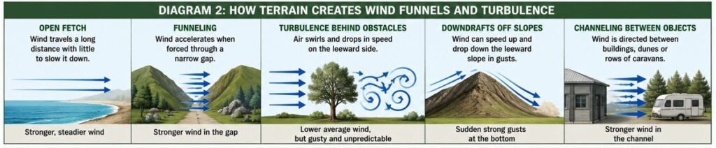
Long open fetch
Fetch is the distance over which wind travels without major obstruction.
A long fetch can occur across:
the sea;
a dam;
open farmland;
a wide valley;
flat Karoo ground;
or a treeless plateau.
The longer the open path, the fewer obstacles there are to slow the airflow.
Waterfront campsites and exposed veld stands may therefore receive stronger, steadier wind.
Narrow gaps and wind funnels
Wind may accelerate when forced through a narrow area.
Possible funnels include:
mountain passes;
valleys;
gaps between dunes;
roads through dense vegetation;
spaces between buildings;
and rows of caravans.
A stand surrounded by obstacles is not always protected. It may be positioned directly in the airflow channel.
Ridges
Wind often strengthens near the top of an exposed ridge.
After passing over the ridge, it may become turbulent and roll down the leeward slope in irregular gusts.
A campsite just below the sheltered side may therefore experience:
sudden downward airflow;
brief reversals;
alternating calm and strong gusts;
and wind from unexpected angles.
Trees
Trees can reduce the average wind speed, but they can also create turbulence.
Campers should consider:
dead branches;
leaning trees;
damaged trunks;
shallow roots;
wet soil;
and the distance between the tree and the tent.
Camping directly below a large tree may replace one wind risk with a falling-branch risk.
Buildings and walls
Buildings may provide useful shelter, but wind tends to accelerate around their edges and corners.
The area directly behind a solid wall may also contain swirling airflow.
A better sheltered position may be some distance behind a broad obstacle rather than immediately against it.
Other caravans
Rows of caravans can create narrow wind channels.
Wind may be redirected:
between caravans;
under awnings;
over roofs;
and around the front or rear corners.
A caravan can protect part of an attached tent while directing more wind towards another section.
Water
Large bodies of water provide a clear path for the wind.
They can also create local temperature differences that contribute to sea or lake breezes.
A stand beside a dam, river mouth or lagoon may experience:
stronger open-fetch wind;
afternoon onshore airflow;
and night-time direction changes.
8. How Wind Loads the Tent, Poles, Ropes and Pegs
A tent is a complete load-carrying system.
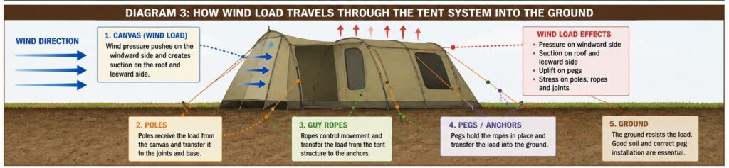
Wind pressure moves through the structure in a chain:
Canvas → poles → joints → guy ropes → pegs → ground
If one part fails, the other parts may no longer carry the load correctly.
Pressure on the windward side
The side facing the approaching wind is the windward side.
When wind strikes this side, pressure builds against the canvas.
A large, nearly vertical wall normally catches more wind than:
a narrow end;
a rounded surface;
or a low sloping roof.
This does not mean the narrow end should always face the wind. Tent design, doors, windows, roof shape and pole layout also matter.
Suction on the roof and leeward side
Wind does not only push the tent.
As air moves over the roof and around the sides, lower pressure can develop on the roof and leeward side.
The result may include:
roof uplift;
outward pressure on the leeward wall;
upward pull on pegs;
and extra stress on seams and connections.
A simple representation is:
Wind → pressure on front | tent | suction behind and above
Wind entering through openings
An open windward door or window can allow air into the tent.
This may increase internal pressure and make the roof and walls push outward.
The advice to “open everything and let the wind pass through” is therefore not a safe universal rule.
The correct approach depends on the tent’s design and the direction of the airflow.
Pole bending
Tent poles are expected to flex to some extent.
A smooth bend spread over a reasonable length is different from a sharp bend concentrated at one point.
A localised bend may indicate:
a weak joint;
previous damage;
a dent;
an unsupported section;
poor alignment;
or the beginning of buckling.
Mid-span buckling
A long pole under compression may suddenly bend sideways at its weakest unsupported point.
This is known as buckling.
Once buckling begins, the pole can rapidly lose its ability to carry the load.
Long unsupported pole sections are generally more vulnerable than shorter, well-supported sections.
Reinforcement can help support a weak area, but it does not remove the wind load. The load still needs to move safely through the rest of the tent system.
Guy ropes
Guy ropes help control movement and transfer load to the ground.
Their effectiveness depends on:
placement;
angle;
tension;
rope condition;
attachment strength;
and the anchor.
A loose rope may allow excessive movement. An overtightened rope may place constant stress on the tent and reduce the structure’s ability to flex.
The aim is controlled support, not simply maximum tension.
Pegs and ground anchors
The strongest poles and ropes cannot help if the pegs pull out.
Anchor performance depends on:
soil type;
peg shape;
peg length;
installation angle;
depth;
direction of pull;
and moisture.
Loose sand, hard clay, gravel and wet soil behave differently.
An anchor may resist a steady sideways pull but loosen when repeated gusts pull upward.
Rain and wet ground
Rain can weaken an anchoring system during the storm.
Dry ground may hold a peg securely at first. Once saturated, the same peg may begin moving.
Water flowing around an anchor can also enlarge the hole.
Water collecting on the roof
A sagging roof can hold water.
The added weight:
increases pole load;
changes the roof angle;
stretches the canvas;
and may create a larger surface for the wind to catch.
Correct roof tension is therefore part of both rain and wind preparation.
Duration
Wind damage is not always caused by one dramatic gust.
Several hours of moderate wind can gradually:
loosen pegs;
stretch ropes;
shift poles;
wear canvas against metal;
and fatigue joints.
A tent that survived the first hour still needs to be checked later.
9. How to Read an Hourly Wind Forecast
A daily weather symbol is not enough for campsite planning.
Use the hourly forecast and look at several different measurements.
Average wind speed
This shows the general wind expected during the hour.
It helps identify whether conditions will be:
light;
breezy;
persistently windy;
or strengthening.
Gust speed
The gust speed shows the strongest brief increases expected.
Compare these examples:
Forecast A
average: 30 km/h;
gusts: 38 km/h.
Forecast B
average: 18 km/h;
gusts: 60 km/h.
Forecast B has the lower average but the greater risk of sudden structural loading.
Wind direction
Wind is named according to where it comes from.
A north wind comes from the north and blows towards the south.
A south-westerly wind comes from the south-west and blows towards the north-east.
Weather apps do not always display arrows in the same way. Check whether the arrow shows where the wind comes from or where it is going.
Hourly direction changes
Do not check only the direction at the time of arrival.
Look for changes over the following:
afternoon;
evening;
night;
and next morning.
A wind that begins from the north-west may change to the south-west after a cold front.
A hot offshore coastal wind may be replaced by cooler onshore airflow.
Timing of the strongest wind
Check when:
gusts increase;
the direction changes;
rain begins;
thunderstorms are expected;
and temperatures fall.
Strong wind arriving at 02:00 requires a different level of preparation from wind arriving while everyone is awake.
Thunderstorm risk
A low average wind forecast does not rule out a powerful local thunderstorm gust.
When storms are possible, also check:
official warnings;
radar where available;
lightning activity;
and changing cloud near the campsite.
Forecast uncertainty
Different apps may use different weather models and update at different times.
When forecasts disagree significantly, do not simply choose the most pleasant result.
Prepare for the stronger realistic outcome, especially at an exposed campsite.
Is there a safe wind speed for tents?
There is no single wind speed below which every tent is safe.
The outcome depends on:
tent size;
design;
age;
condition;
gust speed;
wind angle;
anchoring;
terrain;
soil;
rain;
and pitch quality.
Manufacturer guidance for the specific tent is more useful than a general number shared between campers.
10. How to Assess a Campsite Before Pitching
Wind preparation should begin before the tent is unpacked.
Look beyond the view
An open view across the sea, dam or valley may also mean long wind exposure.
Check all sides of the stand for:
open water;
fields;
valleys;
roads;
mountain gaps;
tree lines;
buildings;
and other caravans.
Ask where the wind could come from later, not only where it is coming from now.
Look for evidence of previous wind
The site may already show which direction is commonly exposed.
Possible clues include:
leaning trees;
broken branches;
bent shade structures;
repaired fences;
scoured ground;
damaged awnings;
and unusually bare areas.
Campsite managers and regular visitors may also know which stands are exposed during specific winds.
Check the ground
Test the ground at several points.
One part of the stand may contain deep soil, while another has:
rock;
gravel;
old concrete;
loose fill;
or soft sand.
Also consider what will happen after rain.
Identify wind funnels
Look for narrow spaces aligned with:
a road;
river;
valley;
gap in the trees;
space between buildings;
or caravan row.
These can direct wind towards the tent.
Check overhead hazards
Do not pitch below:
dead branches;
damaged trees;
loose roof sheets;
unstable signs;
or anything likely to become airborne.
Consider the full tent shape
When choosing orientation, consider:
the broadest wall;
roof slope;
doors;
windows;
pole arrangement;
guy-rope positions;
the caravan connection;
and possible direction changes.
There is no one orientation rule that works for every tent.
Leave enough working space
Make sure important ropes and anchors can be reached and inspected.
Do not place them where:
cars will drive over them;
people will trip over them;
or neighbouring campers will disturb them.
Identify safer shelter
Before severe weather arrives, know where to go.
Possible options include:
a solid ablution building;
a reception building;
another approved storm-safe structure;
or a vehicle when appropriate.
A tent should not be treated as secure shelter during severe wind, lightning or falling branches.
11. Warning Signs After the Tent Has Been Pitched
Small changes can warn that the system is beginning to lose support.
Increasing canvas movement
Watch for:
repeated snapping;
deep inward movement;
roof lifting;
loose panels;
or ballooning on the leeward side.
Movement that becomes progressively larger may mean tension or support is being lost.
A pole developing a sharp bend
A smooth curve across the length of a pole is different from a sharp bend at one point.
A localised bend may show:
a weak section;
a joint problem;
poor alignment;
or the beginning of buckling.
Guy ropes becoming slack
A rope that repeatedly changes between very tight and loose may indicate excessive movement.
Also check whether:
the peg is moving;
the tensioner is slipping;
the knot is loosening;
or the tent attachment point is stretching.
Pegs moving in the ground
Look for:
widening holes;
soil lifting;
changed peg angles;
and ropes losing tension.
Check the windward anchors first, but do not ignore the leeward side. Suction and uplift can place heavy loads there as well.
Changes in sound
A change in the sound of the wind may arrive before the stronger airflow reaches the tent.
Listen for:
a growing roar through trees;
repeated snapping;
poles knocking;
canvas rubbing;
and loose metal components.
An unusual calm period near a thunderstorm may also be followed by a strong gust front.
Dust or leaves moving in a line
A visible line of dust, leaves or grass movement can indicate an approaching gust front.
Act before the rain reaches the campsite.
Sudden temperature changes
A sharp temperature drop may indicate rain-cooled thunderstorm air.
A sudden hot, dry change near the coast may indicate berg-wind conditions or an approaching weather transition.
Changing cloud
Watch for:
rapidly growing thunderstorm towers;
dark cloud bases;
low ragged cloud;
shelf-like cloud;
and fast-moving cloud over ridges.
Visual signs should support weather forecasts and warnings, not replace them.
When to stop protecting the equipment
People are more important than tents and awnings.
Move to safer shelter when there is a serious risk from:
severe wind;
lightning;
falling branches;
airborne debris;
or structural collapse.
Do not remain inside a failing tent to hold poles or ropes.
12. Common Wind Myths That Can Mislead Campers
Simple rules are attractive, but they often ignore important conditions.
Myth: The average wind speed tells me whether the tent is safe
The average does not show the strongest gusts.
A low average with violent gusts may be harder on a tent than a stronger but steadier wind.
Myth: The wind will keep coming from the same direction
Fronts, thunderstorms, sea breezes and terrain can all change the direction.
The least protected side may later become the windward side.
Myth: Trees always provide safe shelter
Trees can reduce average wind but create turbulence and falling-branch hazards.
Tree condition and distance matter.
Myth: Opening the tent allows the wind to pass through
A large windward opening may increase internal pressure and uplift.
The correct approach depends on the tent design.
Myth: Stronger poles solve the wind problem
Poles are only one part of the system.
The next weak point may be:
a peg;
rope;
seam;
joint;
attachment point;
or the ground.
Myth: If the tent survives the first gusts, it will survive the night
Wind can loosen the setup gradually.
The speed and direction may also change later.
Myth: A calm campsite means the forecast is wrong
The site may be temporarily sheltered or experiencing a lull.
Stronger air may exist above the trees or behind an approaching weather system.
Myth: Twice the wind means twice the force
Under similar conditions, doubling the wind speed can create roughly four times the aerodynamic force.
Myth: One wind-speed limit applies to every tent
Different tents, poles, anchors, soils and pitches behave differently.
There is no universal safe limit.
13. A Practical Wind-Readiness Checklist
Understanding wind is useful only when it changes how you prepare.
Before leaving home
Check:
the regional forecast;
hourly average wind;
gust speed;
wind direction;
direction changes;
thunderstorm risk;
cold fronts;
official warnings;
and overnight conditions.
Inspect:
poles;
joints;
guy ropes;
tensioners;
pegs;
anchor plates;
seams;
and attachment points.
Replace damaged parts before the trip.
When arriving
Check:
open sides of the campsite;
nearby water;
hills and valleys;
gaps between trees;
buildings;
overhead branches;
ground conditions;
and drainage.
Ask the campsite manager which stands are most exposed during the forecast wind.
While pitching
Make sure:
poles are fitted correctly;
joints are fully engaged;
canvas tension is even;
roof water can drain;
ropes pull in useful directions;
anchors suit the ground;
and all exposed sides are supported.
Prepare for the forecast overnight direction, not only the current afternoon breeze.
Before going to sleep
Recheck:
the latest forecast;
warnings;
peg movement;
rope tension;
loose equipment;
doors;
windows;
awnings;
and shade cloth.
Secure or pack away:
chairs;
tables;
braai equipment;
washing;
containers;
and other loose items.
During increasing wind
Monitor:
gust strength;
direction changes;
canvas movement;
pole shape;
ropes;
pegs;
nearby trees;
and approaching cloud.
Make adjustments early, before the tent begins moving violently.
After rain starts
Check whether:
the soil has softened;
pegs are moving;
water is collecting on the roof;
ropes have stretched;
or runoff is weakening anchor points.
After the wind
Inspect for:
bent poles;
small cracks;
loose joints;
stretched ropes;
damaged seams;
worn canvas;
and enlarged anchor holes.
A part may have survived the storm but still be weakened.
The Most Important Question Is Not Only How Strong the Wind Will Be
Wind speed is only one part of campsite safety.
Campers should ask:
Where will the wind come from, how suddenly could it change, what will the landscape do to it, and which part of the setup will carry the load?
The same forecast can produce very different conditions.
A tent beside open water may receive strong, steady airflow. A tent behind trees may receive slower but more turbulent gusts. A tent in a valley may be protected from one direction but exposed when the wind turns and is funnelled along the valley.
Think of the wind as a complete chain:
Weather system → region → season → time of day → terrain → tent shape → poles and ropes → anchors and ground
The forecast tells you what may be coming.
The campsite tells you how it may arrive.
The quality of the setup determines how well the tent handles it.